| No |
Title/description |
Length |
| 1 |
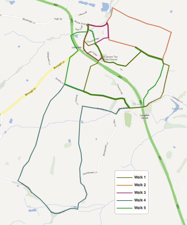
Longdon Way: This route takes a circular route to the south east of the village, mainly across open farmland with some sections along country roads. Gentle elevation. (Map) |
2.5m 4km |
| 2 |
Brook Walk: A circular family walk, through Longdon Village and fields to the east with views of St. James’ Church and countryside. Gentle elevation. (Map) |
1.5m 2.5km |
| 3 |
Longdon Short Walk: This walk has been devised for those less agile who cannot climb stiles or gates, but still like to walk for relaxation. There are only kissing gates to walk through. (Map) |
0.85m 1.3km |
| 4 |
Stoneywell Way: A circular walk to the south of Longdon Village designed for the more agile, with a number of stiles. Dogs may need to be lifted over some stiles. There is a mixture of fields with crops (some tall in summer), sheep, cows and horses. (Map) |
3.2m 5.2km |
| 5 |
Hill Top Way: This walk takes a circular route to the south and east of the village using a mixture of metalled roads and open farmland. Gentle elevation. (Map) |
2.25m 3.5km |
| 7 |
Upper Longdon Way: This walk encircles the hamlet of Upper Longdon using a mixture of minor metalled roads, an old coach road and footpaths across undulating farmland and woodland, via a number of horse paddocks. (Map) |
2.75m 4.5km |
| 8 |
Gentleshaw Chapel Lane Way: This short walk takes a circular route to the south east of the village using a mixture of minor metalled roads and footpaths, across undulating farmland and quiet woodland. (Map) |
1.75m 2.75km |
| 9 |
Anglesey Estate Way: A circular walk to the south east of Upper Longdon via the hamlet of Red Hill and onto the Grand Lodge of Beaudesert (Map) |
3m 5km |
